University of Maryland 1856

Home

  • Linkedin
  • Facebook
  • Twitter
  • YouTube
  • Instagram
  • About Us
    • Leadership
    • People
    • Resources
  • Education
    • Master of Science and Graduate Certificate in Geospatial Intelligence (GEOINT)
    • Master of Science and Graduate Certificate in Geospatial Information Sciences Program
    • Geospatial Information Science Courses
  • Research
    • Current Research
    • Research Spotlight
  • Partners
    • Collaborating with the CGIS
    • Collaborators
    • Support
  • MS GEOINT
  • MS GIS
Enter the terms you wish to search for.

Drone Laser Scanning for Modeling Riverscape Topography and Vegetation

CGIS Hero Image

Dr. Jonathan Resop has just published his manuscript, titled "Drone Laser Scanning for Modeling Riverscape Topography and Vegetation: Comparison with Traditional Aerial Lidar" to the journal Drones. The full text can be accessed for free here: https://www.mdpi.com/2504-446X/3/2/35.


Abstract

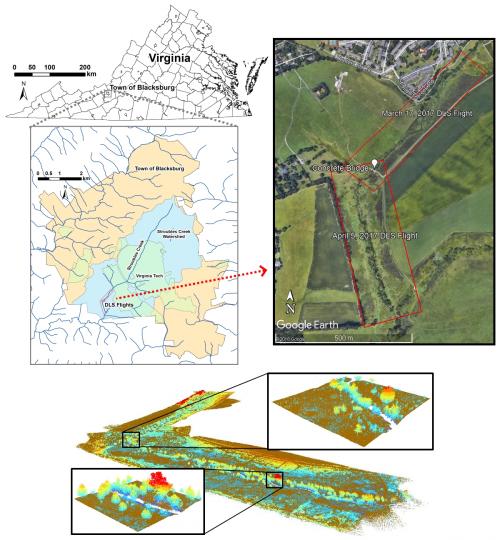
Lidar remote sensing has been used to survey stream channel and floodplain topography for decades. However, traditional platforms, such as aerial laser scanning (ALS) from an airplane, have limitations including flight altitude and scan angle that prevent the scanner from collecting a complete survey of the riverscape. Drone laser scanning (DLS) or unmanned aerial vehicle (UAV)-based lidar offer ways to scan riverscapes with many potential advantages over ALS. We compared point clouds and lidar data products generated with both DLS and ALS for a small gravel-bed stream, Stroubles Creek, located in Blacksburg, VA. Lidar data points were classified as ground and vegetation, and then rasterized to produce digital terrain models (DTMs) representing the topography and canopy height models (CHMs) representing the vegetation. The results highlighted that the lower-altitude, higher-resolution DLS data were more capable than ALS of providing details of the channel profile as well as detecting small vegetation on the floodplain. The greater detail gained with DLS will provide fluvial researchers with better estimates of the physical properties of riverscape topography and vegetation.

Drone Laser Scanning for Modeling Riverscape Topography and Vegetation

Center for Geospatial Information Science
1124 Lefrak Hall, 7251 Preinkert Dr., College Park, MD 20742
Contact Us

  • Give to BSOS
  • College Directory
  • Alumni
  • UMD Web Accessibility
University of Maryland 1856 - College of Behavioral & Social Sciences

Login / Logout